

Features YoPilgrim
Application with which you can configure your own paths.Available in the following languages: Spanish (Spanish, Galician, Catalan and Basque), English, Italian, French, German, Dutch, Portuguese and Hungarian.You will be able to choose from a wide variety of "Caminos de Santiago" from which to plan your next route, establish the date and starting town, as well as the passing towns (where you will spend the night), etc...
the population in the one that will end your path.You have information about the existing services in each transit location (whether there are hostels, bars, restaurants, shops, pharmacies,...) as well as more specific information about the hostels (location, contact) and their characteristics.
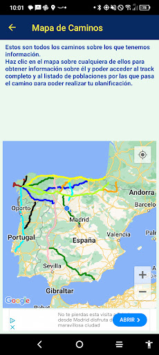
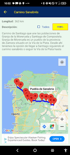
All this accompanied by maps to see the location of the passing towns and hostels as well as the track so as not to get lost.Additionally, height profile information is included, whether for a complete path, a configured path or the profile of each of the stages of your path.One of the differentiating elements of this application is that it has a PATH CALCULATOR that will allow you to plan all the stages of your path in a matter of seconds: Either specifying the start and end town of your path as well as the dates of departure and arrival or by specifying the final town and the days available and the approximate daily kms, it will automatically calculate all the stages (in principle it is intended that the intermediate towns have a hostel or similar accommodation where you can spend the night).Among the available routes are: French, Northern, Primitive, Vía de la Plata, Portuguese (from Lisbon and the Central and Coastal variants from Oporto.
Also the Interior Portuguese from Coimbra), spiritual variant, Sanabrés, route to Madrid, English (from Ferrol and from A Coruña), Finisterre and Muxía, Lebaniego, Vadiniense and Lebaniego Castellano, San Salvador, Mozárabe from Almería, Camino Olvidado,...We are in continuous evolution.
Suggestions, improvements, possible errors are welcome either in the application or in the data displayed.I hope it is useful.Choose your way...Several roads are registered.
From these base paths you can create your own paths.Select your stages...Once you have chosen the base route (French, Primitive, Sanabrés, ...) it is time to configure your starting point and the stages to follow.
This way you can easily see the time you need or the daily distances you must travel.Access services and shelters...You will be able to see the services offered by each passing town: If it has a bar/cafeteria, restaurant, shop, etc...), if there are hostels (municipal, parish or private) and information about them (location, contact information and services offered by each hostel).
And all of them displayed on a map so you can find it more easily.Road calculator...You will quickly be able to obtain a complete plan of your route from the day you leave until the day you finish, seeing the towns where you can spend the night, etc...
To do this you will only have to provide some minimum data (or the starting town and end of your journey and the departure and arrival dates or the days available and the daily kms as well as the town where you decide to end your journey) and by pressing a button you will obtain a list with all the stages day by day that you can later modify to adjust it better to your needs.Good way!-- YoPilgrim app --
Gaming Features
Enjoy immersive gaming experience with various game modes.
Travel Features
Plan and manage your travels with ease.
Food & Dining
Discover recipes and order food from your favorite restaurants.
See the YoPilgrim in Action
Get the App Today
Available for Android 8.0 and above